Location
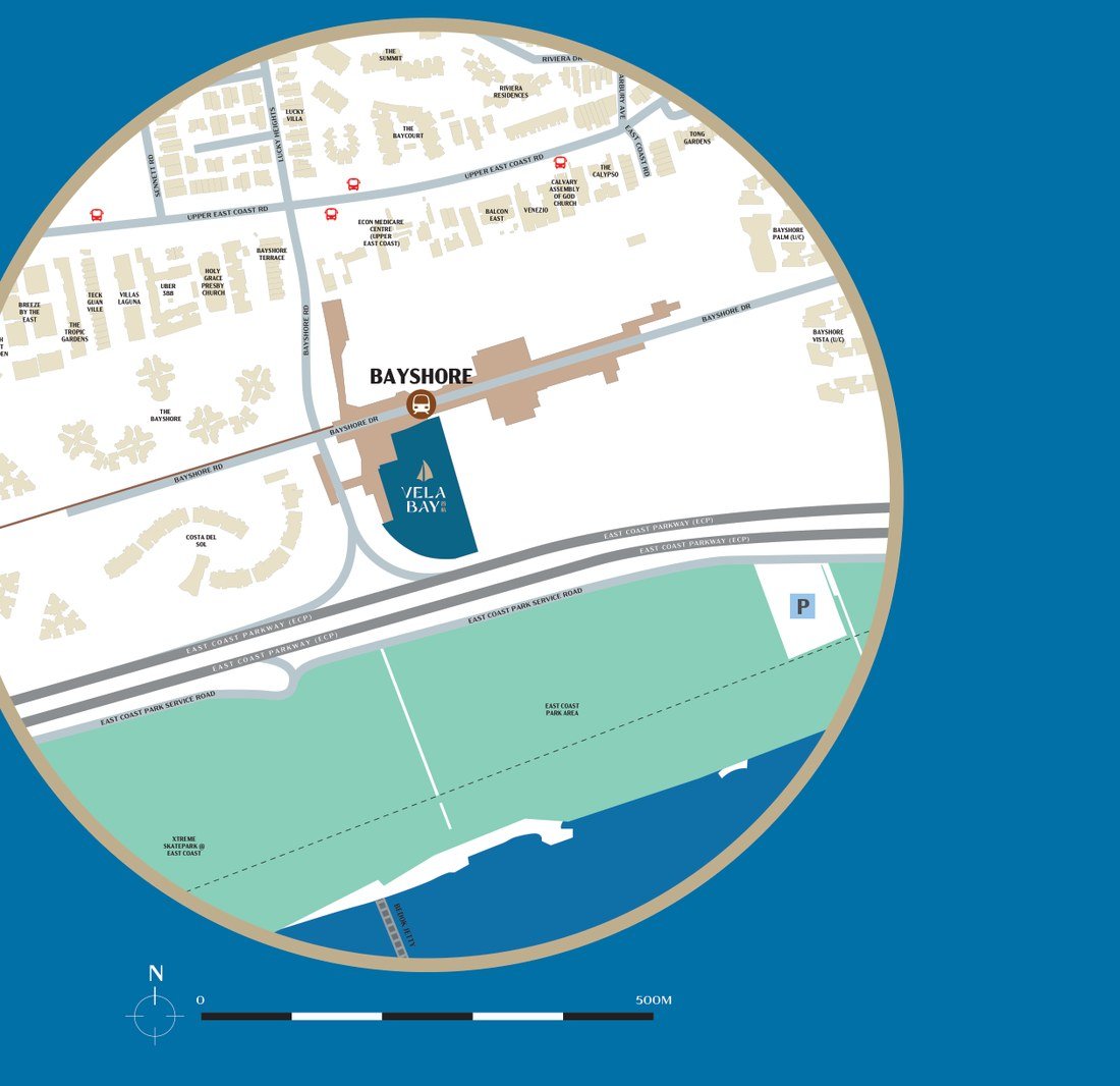
1 and 3 Bayshore Walk, between the station and the park.
What the official sources say, measured and dated — including the one that says nothing at all.
The address
The brochure says Bayshore Drive. The deed will say Bayshore Walk.
The eBook calls this “our Bayshore Drive development” and says “Bay” anchors it “to its Bayshore Drive location”. OneMap has it registered as 1 and 3 Bayshore Walk, postal codes 469861 and 469876, under the building name VELA BAY (U/C). The floor plans’ key plan names Bayshore Road and Bayshore Drive as two of the site’s edges, and the site plan adds Bayshore Walk along a third.
All three roads touch the site. Only one of them is the postal address, and it is the one to use when you search for the place, register interest or check a distance.
| Block | Address | Postal code | Latitude | Longitude |
|---|---|---|---|---|
| Block 1 | 1 Bayshore Walk | Singapore 469861 | 1.311934 | 103.941632 |
| Block 3 | 3 Bayshore Walk | Singapore 469876 | 1.312077 | 103.941588 |
The station
Forty-four metres to Exit 1.
Measured between OneMap’s coordinate for Bayshore MRT Station Exit 1 and its coordinate for 1 Bayshore Walk: 44 metres. To Block 3 it is 46. Exit 2 is 127 m and 118 m; the station box itself is 152 m and 141 m; the furthest of the five exits is 240 m. The site plan draws a side gate on the station side.
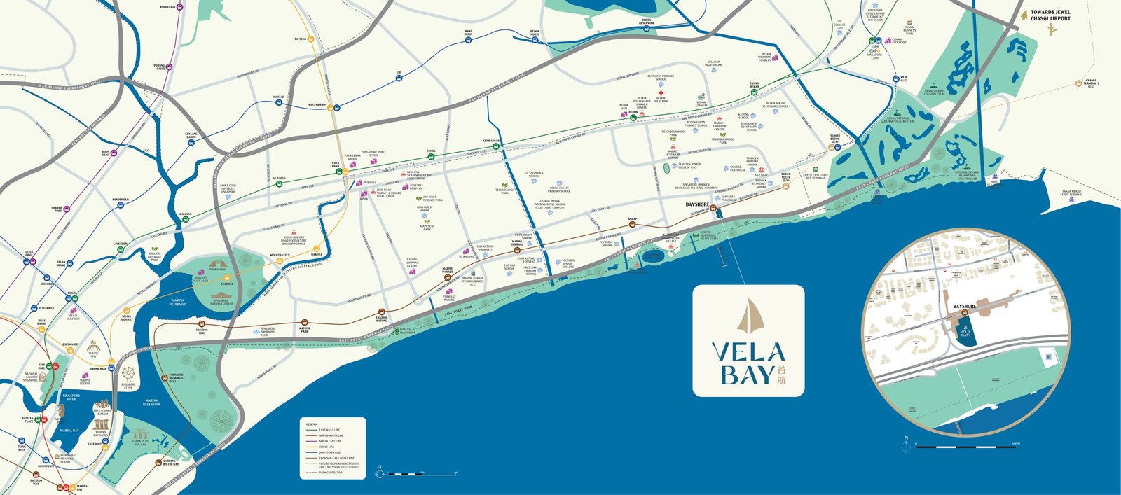
Bayshore is TE29 on the Thomson–East Coast Line, open since 23 June 2024 as one of the seven Stage 4 stations that started service that day. One line, no interchange, to Marina Bay, Shenton Way, Orchard and Outram Park. LTA targets Stage 5 — Bedok South and Sungei Bedok, the latter an interchange with the Downtown Line — for 2026; the developer’s own location map still marks both under construction.
Schools
Checked in both sources, on the same afternoon, with a control.
Before any school-distance claim goes on one of these pages it is checked in OneMap School Query and in MOE SchoolFinder, and both results are recorded with the date. Here is what the two of them returned for Vela Bay on 13 September 2026.
OneMap School Query, 1:13 PM. Address selected from OneMap’s own search as VELA BAY (U/C), 1 Bayshore Walk. Schools within 1 km: No schools found. Schools within 1–2 km: No schools found. Identical for 3 Bayshore Walk.
MOE SchoolFinder, 1:09 PM. Address picked from SchoolFinder’s own autocomplete as “1 BAYSHORE WALK VELA BAY (U/C) SINGAPORE”. Schools within 1 km and schools between 1 and 2 km both returned “There are no schools that match your criteria”, over a footnote saying the information is accurate as of Sunday, 13 September 2026, 1.09pm, and is next updated in May 2027.
Why that is an absence and not an answer
The service was working. A control address queried in the same minute — 222 Jalan Jurong Kechil, another project on this site — came back with Bukit Timah Primary School at distance code 1 and three more schools in the 1–2km band. The gap is Vela Bay’s record, not OneMap’s afternoon.
The reason is in OneMap’s own disclaimer. Home-School Distance is measured from the building outline in the building plan submitted by the Qualified Person to the nearest point on the school’s land boundary. The published table was built in June 2026, for children entering Primary 1 in 2027. Vela Bay’s building plan is dated 9 February 2026 and both addresses still read “(U/C)”. The next build is June 2027.
And the measurements all point one way. Below, straight-line distances computed from OneMap’s own school-boundary geometry. They are not Home-School Distance and are not a substitute for it — but they are the same two schools the eBook lists, with numbers attached.
| School | Address | To land boundary | To address point | Straight-line band |
|---|---|---|---|---|
| Temasek Primary School | 501 Bedok South Avenue 3, S469300 | 682 m | 763 m | Within 1 km |
| Bedok Green Primary School | 1 Bedok South Avenue 2, S469317 | 1,324 m | 1,408 m | 1 – 2 km |
One more measurement, because it is the clearest of them. Temasek Primary School’s published building layer carries 2,642 building outlines coded within 1 km and 3,004 coded 1–2 km. Vela Bay’s outline is in neither. The nearest outline that is coded within 1 km stands 39 metres from the site.
Two corrections to the education page
The eBook lists Temasek Secondary School under “WITHIN 1 KM”. The one-kilometre band is a Primary 1 registration rule; secondary admission runs on the PSLE posting exercise and has no distance priority, so the heading does not mean for a secondary school what it means for a primary one.
The eBook credits “Source : OneMap” for the whole education page. OneMap’s School Query is the service that would have to say it, and on 13 September 2026 it did not.
The estate
Ten thousand homes are planned here. Five hundred and fifteen of them are these.
HDB unveiled the Bayshore masterplan on 17 October 2023: about 10,000 new homes on a 60-hectare reclaimed site bounded by Upper East Coast Road, Bayshore Road and the East Coast Parkway, earmarked for housing since the 1998 Master Plan. About 7,000 of them — seventy per cent — are public housing, which leaves roughly three thousand private homes across the whole estate. Vela Bay is the first of them.
Car-lite, by designation
HDB designates Bayshore a car-lite estate. Most homes in it are planned to be within a five-minute walk of an MRT station, existing drains from Upper East Coast Road are being converted into pedestrian paths, and a network of walking and cycling paths runs through the estate into the wider Bedok cycling network.
The central street
HDB’s release names the new central street Bayshore Drive — the eBook calls the community spine “Bayshore Street” — lined with shops, eateries, supermarkets and medical facilities, and carrying a 400-metre bus-only Transit Priority Corridor with dedicated cycling paths and wider sheltered pavements.
Parks, and a seawall
A three-hectare central park is planned inside the surrounding housing, designed with NParks, running southward from the estate’s northern edge. A linear park along the edge of the estate retains the old seawalls that mark the former coastline.
A second station
HDB plans the estate around two MRT stations. Bayshore is open; Bedok South is under construction, and an integrated development with a new bus interchange is planned to connect to it.
One claim that could not be verified
The eBook’s master plan page describes “a new landscaped bridge planned across ECP, serving as an elevated gateway linking the neighbourhood to the beachfront”. No such bridge appears in HDB’s masterplan release, which describes the linear park and the converted drain paths instead. It may well be planned; it could not be sourced on 13 September 2026 and so it is not stated here as fact.
The same page describes a “1km-long green corridor”. HDB’s figures are a 400-metre Transit Priority Corridor along Bayshore Drive, a 15 km central green corridor from East Coast Park to Changi Beach Park, and the 150 km Round Island Route.
The map
East Coast Park is across the expressway.
Vela Bay
Ask for what the brochure does not say.
The price list when it lands, the lease commencement date, the expected TOP and the balance of any stack — in writing.